Washington, DC 50 Mile Vicinity Wall Map Available from UniversalMAP
UniversalMAP is proud to announce publication of our wall map of Washington, DC 50 Mile Vicinity Wall Map by ADC.
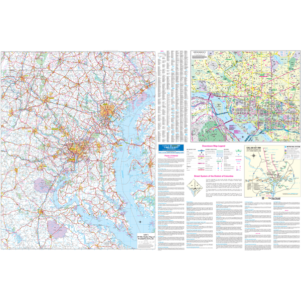
Specifications of this high quality map include: Measures 6' W x 4'2" H (72? x 50?)
Up-to-date cartography at a scale of 1" = 2.66 miles. Printed in color with a markable and washable laminated surface. Hanging options of spring roller; or rails, mounted top and bottom. Cities are indexed on the face of the map, plus index book form.
Areas of Coverage: In Virginia: the counties of Arlington, Fairfax, Loudoun, Prince Williams, King Georges and Stafford with portions of Caroline, Culpepper, Essex, Fauquier, Orange, Richmond, Spotsylvania and Westmoreland. In Maryland: the counties of Anne Arundel, Baltimore, Calvert, Carroll, Charles, with portions of Cecil, Dorchester, Kent, Queen Ann Talbot Counties. Coverage includes North: to Gettysburg Hanover, PA; South: to Fort AP Hill Military Reservation in Caroline county; East: to Chesapeake Bay, including portions of Kent, Queen Ann and Talbot Counties; West: including Martinsburg, WV and city of Warrenton in Fauquier County.
Downtown Washington, DC: Scale of 1" = 900 feet. Compete street detail, Block # Building, List of Major Points of Interest. Coverage includes North: to Washington National Cathedral Howard University; South: Arlington National Cemetery and M Street; East: to 4th Street to include Columbus Circle; West: to Georgetown University.
Details include: Major Streets and All Highways, Airports Parks, Military Institutions, County Lines Names, Water Features Points of Interest.
Year: 2011
Edition: 1st
These maps are printed and finished to order. Please allow 4-6 weeks for delivery.