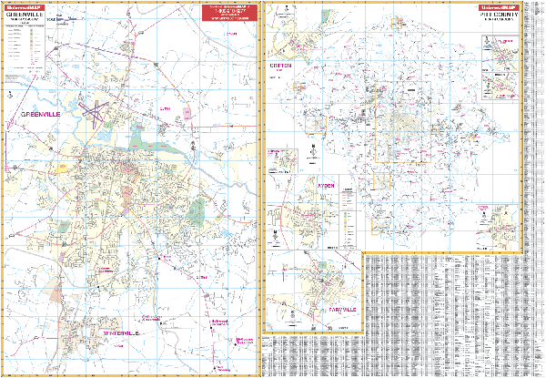
The Greenville and Pitt County, North Carolina Wall Map measures 75? W x 54? H with complete street detail at a scale of 1? = approx. .285 miles for Greenville and 1? = approx. 1.06 miles for Pitt County. Includes up-to-date cartography with new streets and changes. Printed in color with a markable/washable-laminated surface. Streets indexed on the map?s face. Provided with hanging rails mounted top and bottom.
Area of Coverage: all of Greenville and Pitt County with the following boundaries: North: to ?® mile north of the junction of US 13 and SR 903; South: includes all of Winterville; East: to 2 miles beyond Greenville Blvd, Bradford Creek Golf Course; West: to the junction of US 264 and Business 264. Inset maps: Greenville and Pitt County are the two main maps; insets of Grifton, Fountain, Grimesland, Bethel, Farmville, Ayden, and Simpson.
Details included are airports, hospitals, cemeteries, railroads, post offices, longitude/latitude, all streets/highways, shopping centers, water features, recreational parks, mileage circles, school district lines, section/township/range lines, government buildings, fire/police stations, educational facilities, golf course/country clubs, ZIP codes/boundaries, city limits/annexations, and points of interest.
Railed wall maps can be turned into pull down maps on spring rollers for an additional $30.
Year: 2000
Edition: 1st
These maps are printed and finished to order. Please allow 4-6 weeks for delivery.