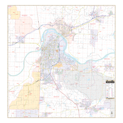
Our Fort Smith, AR Wall Map, with surrounding areas, measures 4' 11? W x 5' 1" H (59? x 61?) and features up-to-date cartography with new streets and changes in complete street detail at a scale 1? = 2,167 feet. Printed in color with a markable and washable laminated surface. Streets are indexed in a separate book.
The area of coverage includes all of Fort Smith and the surrounding communities, with the following boundaries:
- North to include all of the City of Alma in Crawford County
- South to include all of the City of Hackett and Greenwood in Sebastian County
- East to include all of the City of Lavaca in Sebastian County
- West to include all of the Town of Pocola in Le Flore County, OK and the Town of Roland in Sequoyah County, OK
Details and features include:
Airports, All Streets Highways, Government Buildings, Cemeteries, Shopping Centers, Fire Police Stations, Hospitals, Water Features, Educational Institutions, Railroads, Recreational Parks, Golf Country Clubs, Block Numbers, Post Offices, Points of Interest, Color Coded City and Town Boundaries, Zip Codes Boundaries, Twp/Sec/Range Lines Numbers
Framing rails are included, top and bottom, for easy wall mounting. Spring roller mounting is also available, for an additional $30.
Year: 2014
Edition: 1st
These maps are printed and finished to order. Please allow 4-6 weeks for delivery.