bell
user
minus
plus
bars
file-lines
cart-shopping
magnifying-glass
magnifying-glass-plus
bag-shopping
arrow-left
arrow-right
angle-down
globe
angle-right
calendar
star
star-half
check
sliders
caret-down
arrow-square
x
exclamation
box
pen
box-open
store
location-dot
trash
circle-play
cube
play
tag
lock
twitter
facebook
pinterest
instagram
snapchat
youtube
vimeo
shopify
tumblr
tiktok
star-empty
Subscribe to our emails
Be the first to know about new collections and exclusive offers.
Home
Products
Contact Us
About us
Shop
Menu
Products
Globes
Raised Relief Maps
Geochron
Nautical
Wall Maps
Shop
Globes
Floor Globes
Desk Globes
Children's Globes
Inflatable Globes
Raised Relief Maps
World Raised Relief Maps
International Raised Relief Maps
United States Raised Relief Maps
US States Raised Relief Maps
USGS Regional Raised Relief Maps
National Park Raised Relief Maps
Ski Resorts
Specialty Raised Relief Maps
Geochron
Nautical
NOAA Nautical Charts
Canadian Nautical Charts
Wall Maps
World & Foreign
United States
US Regions
US States
City and County
Classroom
Home and Office Decor
Satellite and Space Image Posters
Classroom Maps
Advanced (Grades 6-12)
Essential (Grades 4-8)
Primary (Grades K-3)
Beginner (Grades PreK-1)
History
Shaded Relief
State Thematic
Raised Relief Maps
World Raised Relief Maps
International Raised Relief Maps
United States Raised Relief Maps
US States Raised Relief Maps
USGS Regional Raised Relief Maps
National Park Raised Relief Maps
Specialty Raised Relief Maps
Satellite and Space image Poster
Products
Nautical
NOAA Nautical Charts
Canadian Nautical Charts
Logo
800-248-6277
United States (USD $)
Afghanistan (USD $)
Åland Islands (USD $)
Albania (USD $)
Algeria (USD $)
Andorra (USD $)
Angola (USD $)
Anguilla (USD $)
Antigua & Barbuda (USD $)
Argentina (USD $)
Armenia (USD $)
Aruba (USD $)
Ascension Island (USD $)
Australia (USD $)
Austria (USD $)
Azerbaijan (USD $)
Bahamas (USD $)
Bahrain (USD $)
Bangladesh (USD $)
Barbados (USD $)
Belarus (USD $)
Belgium (USD $)
Belize (USD $)
Benin (USD $)
Bermuda (USD $)
Bhutan (USD $)
Bolivia (USD $)
Bosnia & Herzegovina (USD $)
Botswana (USD $)
Brazil (USD $)
British Indian Ocean Territory (USD $)
British Virgin Islands (USD $)
Brunei (USD $)
Bulgaria (USD $)
Burkina Faso (USD $)
Burundi (USD $)
Cambodia (USD $)
Cameroon (USD $)
Canada (USD $)
Cape Verde (USD $)
Caribbean Netherlands (USD $)
Cayman Islands (USD $)
Central African Republic (USD $)
Chad (USD $)
Chile (USD $)
China (USD $)
Christmas Island (USD $)
Cocos (Keeling) Islands (USD $)
Colombia (USD $)
Comoros (USD $)
Congo - Brazzaville (USD $)
Congo - Kinshasa (USD $)
Cook Islands (USD $)
Costa Rica (USD $)
Côte d’Ivoire (USD $)
Croatia (USD $)
Curaçao (USD $)
Cyprus (USD $)
Czechia (USD $)
Denmark (USD $)
Djibouti (USD $)
Dominica (USD $)
Dominican Republic (USD $)
Ecuador (USD $)
Egypt (USD $)
El Salvador (USD $)
Equatorial Guinea (USD $)
Eritrea (USD $)
Estonia (USD $)
Eswatini (USD $)
Ethiopia (USD $)
Falkland Islands (USD $)
Faroe Islands (USD $)
Fiji (USD $)
Finland (USD $)
France (USD $)
French Guiana (USD $)
French Polynesia (USD $)
French Southern Territories (USD $)
Gabon (USD $)
Gambia (USD $)
Georgia (USD $)
Germany (USD $)
Ghana (USD $)
Gibraltar (USD $)
Greece (USD $)
Greenland (USD $)
Grenada (USD $)
Guadeloupe (USD $)
Guatemala (USD $)
Guernsey (USD $)
Guinea (USD $)
Guinea-Bissau (USD $)
Guyana (USD $)
Haiti (USD $)
Honduras (USD $)
Hong Kong SAR (USD $)
Hungary (USD $)
Iceland (USD $)
India (USD $)
Indonesia (USD $)
Iraq (USD $)
Ireland (USD $)
Isle of Man (USD $)
Israel (USD $)
Italy (USD $)
Jamaica (USD $)
Japan (USD $)
Jersey (USD $)
Jordan (USD $)
Kazakhstan (USD $)
Kenya (USD $)
Kiribati (USD $)
Kosovo (USD $)
Kuwait (USD $)
Kyrgyzstan (USD $)
Laos (USD $)
Latvia (USD $)
Lebanon (USD $)
Lesotho (USD $)
Liberia (USD $)
Libya (USD $)
Liechtenstein (USD $)
Lithuania (USD $)
Luxembourg (USD $)
Macao SAR (USD $)
Madagascar (USD $)
Malawi (USD $)
Malaysia (USD $)
Maldives (USD $)
Mali (USD $)
Malta (USD $)
Martinique (USD $)
Mauritania (USD $)
Mauritius (USD $)
Mayotte (USD $)
Mexico (USD $)
Moldova (USD $)
Monaco (USD $)
Mongolia (USD $)
Montenegro (USD $)
Montserrat (USD $)
Morocco (USD $)
Mozambique (USD $)
Myanmar (Burma) (USD $)
Namibia (USD $)
Nauru (USD $)
Nepal (USD $)
Netherlands (USD $)
New Caledonia (USD $)
New Zealand (USD $)
Nicaragua (USD $)
Niger (USD $)
Nigeria (USD $)
Niue (USD $)
Norfolk Island (USD $)
North Macedonia (USD $)
Norway (USD $)
Oman (USD $)
Pakistan (USD $)
Palestinian Territories (USD $)
Panama (USD $)
Papua New Guinea (USD $)
Paraguay (USD $)
Peru (USD $)
Philippines (USD $)
Pitcairn Islands (USD $)
Poland (USD $)
Portugal (USD $)
Qatar (USD $)
Réunion (USD $)
Romania (USD $)
Russia (USD $)
Rwanda (USD $)
Samoa (USD $)
San Marino (USD $)
São Tomé & Príncipe (USD $)
Saudi Arabia (USD $)
Senegal (USD $)
Serbia (USD $)
Seychelles (USD $)
Sierra Leone (USD $)
Singapore (USD $)
Sint Maarten (USD $)
Slovakia (USD $)
Slovenia (USD $)
Solomon Islands (USD $)
Somalia (USD $)
South Africa (USD $)
South Georgia & South Sandwich Islands (USD $)
South Korea (USD $)
South Sudan (USD $)
Spain (USD $)
Sri Lanka (USD $)
St. Barthélemy (USD $)
St. Helena (USD $)
St. Kitts & Nevis (USD $)
St. Lucia (USD $)
St. Martin (USD $)
St. Pierre & Miquelon (USD $)
St. Vincent & Grenadines (USD $)
Sudan (USD $)
Suriname (USD $)
Svalbard & Jan Mayen (USD $)
Sweden (USD $)
Switzerland (USD $)
Taiwan (USD $)
Tajikistan (USD $)
Tanzania (USD $)
Thailand (USD $)
Timor-Leste (USD $)
Togo (USD $)
Tokelau (USD $)
Tonga (USD $)
Trinidad & Tobago (USD $)
Tristan da Cunha (USD $)
Tunisia (USD $)
Türkiye (USD $)
Turkmenistan (USD $)
Turks & Caicos Islands (USD $)
Tuvalu (USD $)
U.S. Outlying Islands (USD $)
Uganda (USD $)
Ukraine (USD $)
United Arab Emirates (USD $)
United Kingdom (USD $)
Uruguay (USD $)
Uzbekistan (USD $)
Vanuatu (USD $)
Vatican City (USD $)
Venezuela (USD $)
Vietnam (USD $)
Wallis & Futuna (USD $)
Western Sahara (USD $)
Yemen (USD $)
Zambia (USD $)
Zimbabwe (USD $)
USD
United States (USD $)
Afghanistan (USD $)
Åland Islands (USD $)
Albania (USD $)
Algeria (USD $)
Andorra (USD $)
Angola (USD $)
Anguilla (USD $)
Antigua & Barbuda (USD $)
Argentina (USD $)
Armenia (USD $)
Aruba (USD $)
Ascension Island (USD $)
Australia (USD $)
Austria (USD $)
Azerbaijan (USD $)
Bahamas (USD $)
Bahrain (USD $)
Bangladesh (USD $)
Barbados (USD $)
Belarus (USD $)
Belgium (USD $)
Belize (USD $)
Benin (USD $)
Bermuda (USD $)
Bhutan (USD $)
Bolivia (USD $)
Bosnia & Herzegovina (USD $)
Botswana (USD $)
Brazil (USD $)
British Indian Ocean Territory (USD $)
British Virgin Islands (USD $)
Brunei (USD $)
Bulgaria (USD $)
Burkina Faso (USD $)
Burundi (USD $)
Cambodia (USD $)
Cameroon (USD $)
Canada (USD $)
Cape Verde (USD $)
Caribbean Netherlands (USD $)
Cayman Islands (USD $)
Central African Republic (USD $)
Chad (USD $)
Chile (USD $)
China (USD $)
Christmas Island (USD $)
Cocos (Keeling) Islands (USD $)
Colombia (USD $)
Comoros (USD $)
Congo - Brazzaville (USD $)
Congo - Kinshasa (USD $)
Cook Islands (USD $)
Costa Rica (USD $)
Côte d’Ivoire (USD $)
Croatia (USD $)
Curaçao (USD $)
Cyprus (USD $)
Czechia (USD $)
Denmark (USD $)
Djibouti (USD $)
Dominica (USD $)
Dominican Republic (USD $)
Ecuador (USD $)
Egypt (USD $)
El Salvador (USD $)
Equatorial Guinea (USD $)
Eritrea (USD $)
Estonia (USD $)
Eswatini (USD $)
Ethiopia (USD $)
Falkland Islands (USD $)
Faroe Islands (USD $)
Fiji (USD $)
Finland (USD $)
France (USD $)
French Guiana (USD $)
French Polynesia (USD $)
French Southern Territories (USD $)
Gabon (USD $)
Gambia (USD $)
Georgia (USD $)
Germany (USD $)
Ghana (USD $)
Gibraltar (USD $)
Greece (USD $)
Greenland (USD $)
Grenada (USD $)
Guadeloupe (USD $)
Guatemala (USD $)
Guernsey (USD $)
Guinea (USD $)
Guinea-Bissau (USD $)
Guyana (USD $)
Haiti (USD $)
Honduras (USD $)
Hong Kong SAR (USD $)
Hungary (USD $)
Iceland (USD $)
India (USD $)
Indonesia (USD $)
Iraq (USD $)
Ireland (USD $)
Isle of Man (USD $)
Israel (USD $)
Italy (USD $)
Jamaica (USD $)
Japan (USD $)
Jersey (USD $)
Jordan (USD $)
Kazakhstan (USD $)
Kenya (USD $)
Kiribati (USD $)
Kosovo (USD $)
Kuwait (USD $)
Kyrgyzstan (USD $)
Laos (USD $)
Latvia (USD $)
Lebanon (USD $)
Lesotho (USD $)
Liberia (USD $)
Libya (USD $)
Liechtenstein (USD $)
Lithuania (USD $)
Luxembourg (USD $)
Macao SAR (USD $)
Madagascar (USD $)
Malawi (USD $)
Malaysia (USD $)
Maldives (USD $)
Mali (USD $)
Malta (USD $)
Martinique (USD $)
Mauritania (USD $)
Mauritius (USD $)
Mayotte (USD $)
Mexico (USD $)
Moldova (USD $)
Monaco (USD $)
Mongolia (USD $)
Montenegro (USD $)
Montserrat (USD $)
Morocco (USD $)
Mozambique (USD $)
Myanmar (Burma) (USD $)
Namibia (USD $)
Nauru (USD $)
Nepal (USD $)
Netherlands (USD $)
New Caledonia (USD $)
New Zealand (USD $)
Nicaragua (USD $)
Niger (USD $)
Nigeria (USD $)
Niue (USD $)
Norfolk Island (USD $)
North Macedonia (USD $)
Norway (USD $)
Oman (USD $)
Pakistan (USD $)
Palestinian Territories (USD $)
Panama (USD $)
Papua New Guinea (USD $)
Paraguay (USD $)
Peru (USD $)
Philippines (USD $)
Pitcairn Islands (USD $)
Poland (USD $)
Portugal (USD $)
Qatar (USD $)
Réunion (USD $)
Romania (USD $)
Russia (USD $)
Rwanda (USD $)
Samoa (USD $)
San Marino (USD $)
São Tomé & Príncipe (USD $)
Saudi Arabia (USD $)
Senegal (USD $)
Serbia (USD $)
Seychelles (USD $)
Sierra Leone (USD $)
Singapore (USD $)
Sint Maarten (USD $)
Slovakia (USD $)
Slovenia (USD $)
Solomon Islands (USD $)
Somalia (USD $)
South Africa (USD $)
South Georgia & South Sandwich Islands (USD $)
South Korea (USD $)
South Sudan (USD $)
Spain (USD $)
Sri Lanka (USD $)
St. Barthélemy (USD $)
St. Helena (USD $)
St. Kitts & Nevis (USD $)
St. Lucia (USD $)
St. Martin (USD $)
St. Pierre & Miquelon (USD $)
St. Vincent & Grenadines (USD $)
Sudan (USD $)
Suriname (USD $)
Svalbard & Jan Mayen (USD $)
Sweden (USD $)
Switzerland (USD $)
Taiwan (USD $)
Tajikistan (USD $)
Tanzania (USD $)
Thailand (USD $)
Timor-Leste (USD $)
Togo (USD $)
Tokelau (USD $)
Tonga (USD $)
Trinidad & Tobago (USD $)
Tristan da Cunha (USD $)
Tunisia (USD $)
Türkiye (USD $)
Turkmenistan (USD $)
Turks & Caicos Islands (USD $)
Tuvalu (USD $)
U.S. Outlying Islands (USD $)
Uganda (USD $)
Ukraine (USD $)
United Arab Emirates (USD $)
United Kingdom (USD $)
Uruguay (USD $)
Uzbekistan (USD $)
Vanuatu (USD $)
Vatican City (USD $)
Venezuela (USD $)
Vietnam (USD $)
Wallis & Futuna (USD $)
Western Sahara (USD $)
Yemen (USD $)
Zambia (USD $)
Zimbabwe (USD $)
Account
Sign in
Cart
0
$ 0.00
Home
Products
Globes
Raised Relief Maps
Geochron
Nautical
NOAA Nautical Charts
Canadian Nautical Charts
Wall Maps
Contact Us
About us
Shop
Globes
Floor Globes
Desk Globes
Children's Globes
Inflatable Globes
Raised Relief Maps
World Raised Relief Maps
International Raised Relief Maps
United States Raised Relief Maps
US States Raised Relief Maps
USGS Regional Raised Relief Maps
National Park Raised Relief Maps
Ski Resorts
Specialty Raised Relief Maps
Geochron
Nautical
NOAA Nautical Charts
Canadian Nautical Charts
Wall Maps
World & Foreign
United States
US Regions
US States
City and County
Classroom
Home and Office Decor
Satellite and Space Image Posters
Classroom Maps
Advanced (Grades 6-12)
Essential (Grades 4-8)
Primary (Grades K-3)
Beginner (Grades PreK-1)
History
Shaded Relief
State Thematic
Raised Relief Maps
World Raised Relief Maps
International Raised Relief Maps
United States Raised Relief Maps
US States Raised Relief Maps
USGS Regional Raised Relief Maps
National Park Raised Relief Maps
Specialty Raised Relief Maps
Satellite and Space image Poster
Home
Collections
Products
Products
3531 products
Sort by:
Featured
Most relevant
Best selling
Alphabetically, A-Z
Alphabetically, Z-A
Price, low to high
Price, high to low
Date, old to new
Date, new to old
Alphabetically, A-Z
Featured
Most relevant
Best selling
Alphabetically, A-Z
Alphabetically, Z-A
Price, low to high
Price, high to low
Date, old to new
Date, new to old
Availability
In stock
2660
Out of stock
874
Globe Type
All
199
Bar
1
Children's
40
Desk
124
Floor
71
Inflatable
7
Illuminated
No
109
Yes
83
Raised Relief
No
118
Yes
81
Globe Size
12
1
27
1
3-10 Inch
22
3-10 inch
2
12-15 inch
90
16-19 Inch
52
20-29 Inch
20
40-49 Inch
3
Globe Color
Antique
2
Antique Ocean
64
Apricot
4
Black
1
Blue
79
Blue Ocean
1
Gray
1
Specialty
39
Raised Relief Category
All
150
International
4
National Park
29
Specialty
33
United States
10
US State
31
USGS Regional
44
USGS Regional Raised Relief Maps
1
World
6
With Coverage In
Alabama
12
Alaska
15
Arizona
14
Arkansas
9
California
37
Colorado
25
Connecticut
7
Delaware
4
Florida
53
Georgia
24
Hawaii
8
Idaho
14
Illinois
19
Indiana
10
Iowa
7
Kansas
10
Kentucky
7
Louisiana
10
Maine
9
Maryland
11
Massachusetts
13
Michigan
20
Minnesota
4
Mississippi
7
Missouri
9
Montana
9
Nebraska
5
Nevada
9
New Hampshire
11
New Jersey
18
New Mexico
6
New York
31
North Carolina
33
North Dakota
4
Ohio
14
Oklahoma
9
Oregon
11
Pennsylvania
17
Rhode Island
7
South Carolina
21
South Dakota
6
Tennessee
25
Texas
32
Utah
18
Vermont
11
Virginia
21
Washington
19
West Virginia
10
Wisconsin
11
Wyoming
9
Price
$ 0
$ 16,950
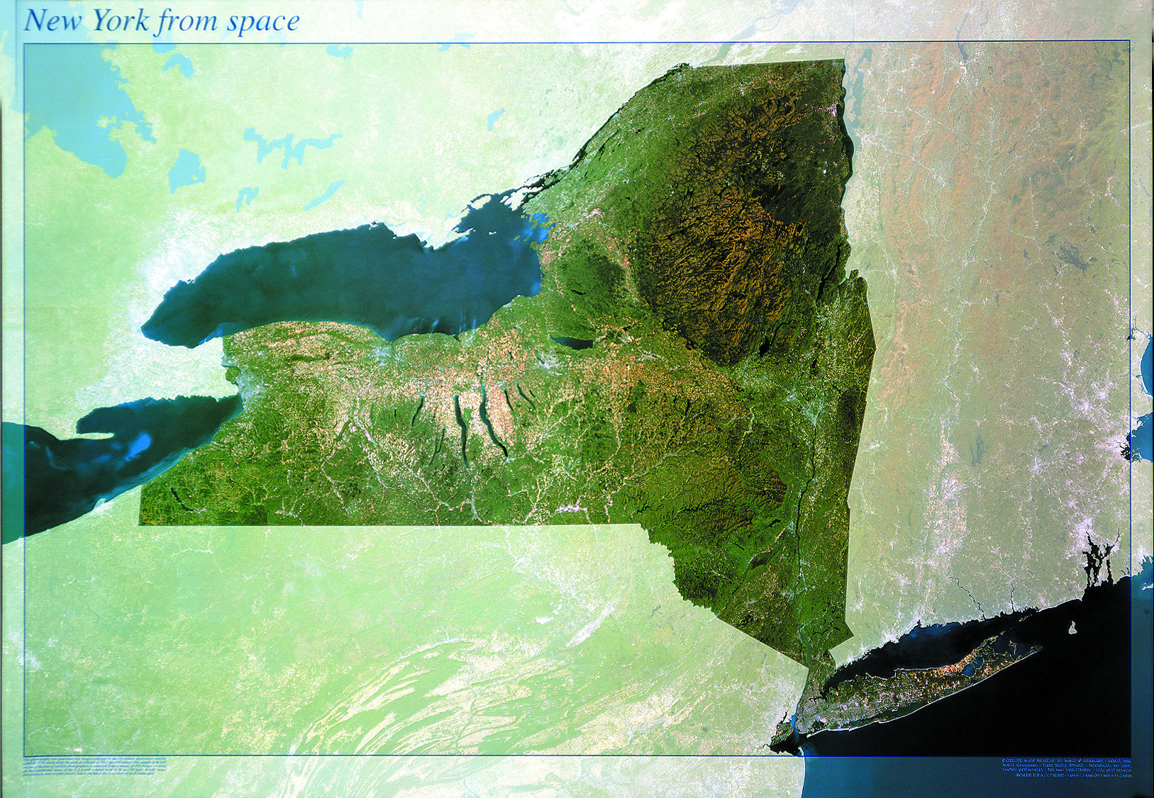
New York State From Space Map
Quick View
New York State From Space Map
Price
$ 12.99
—
$ 26.99
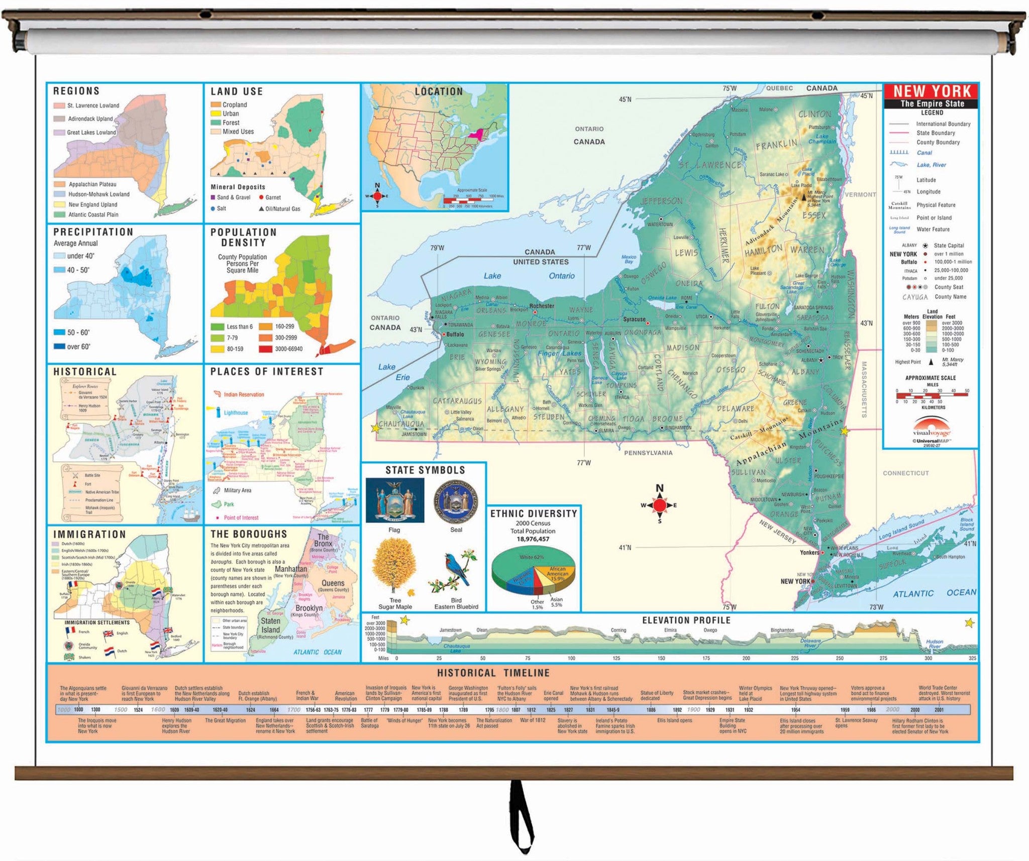
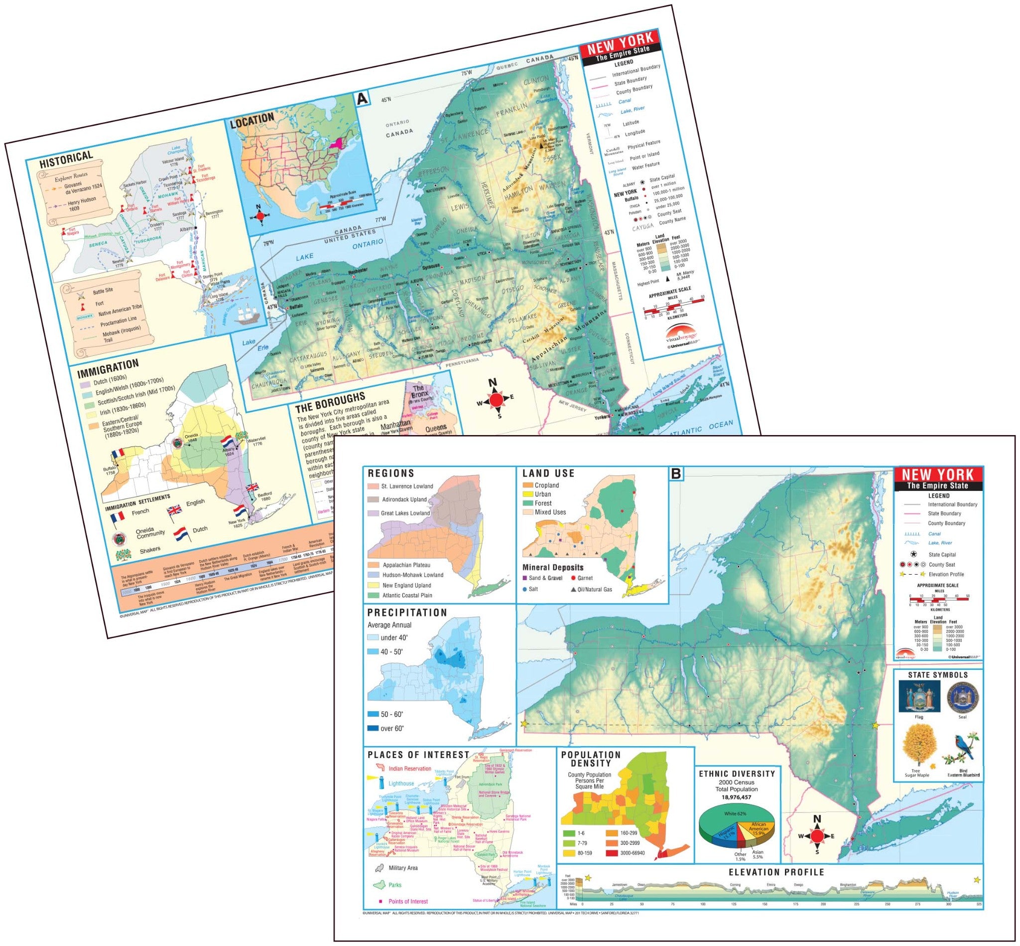
New York State Intermediate Thematic Classroom Wall Map
Sold out
Quick View
New York State Intermediate Thematic Classroom Wall Map
Price
$ 229.95
—
$ 269.95
New York State Intermediate Thematic Deskpad Map (multi-pack)
Sold out
Quick View
New York State Intermediate Thematic Deskpad Map (multi-pack)
Price
$ 39.95
—
$ 229.99
New York State Primary Thematic Classroom Wall Map
Sold out
Quick View
New York State Primary Thematic Classroom Wall Map
Price
$ 229.95
—
$ 269.95
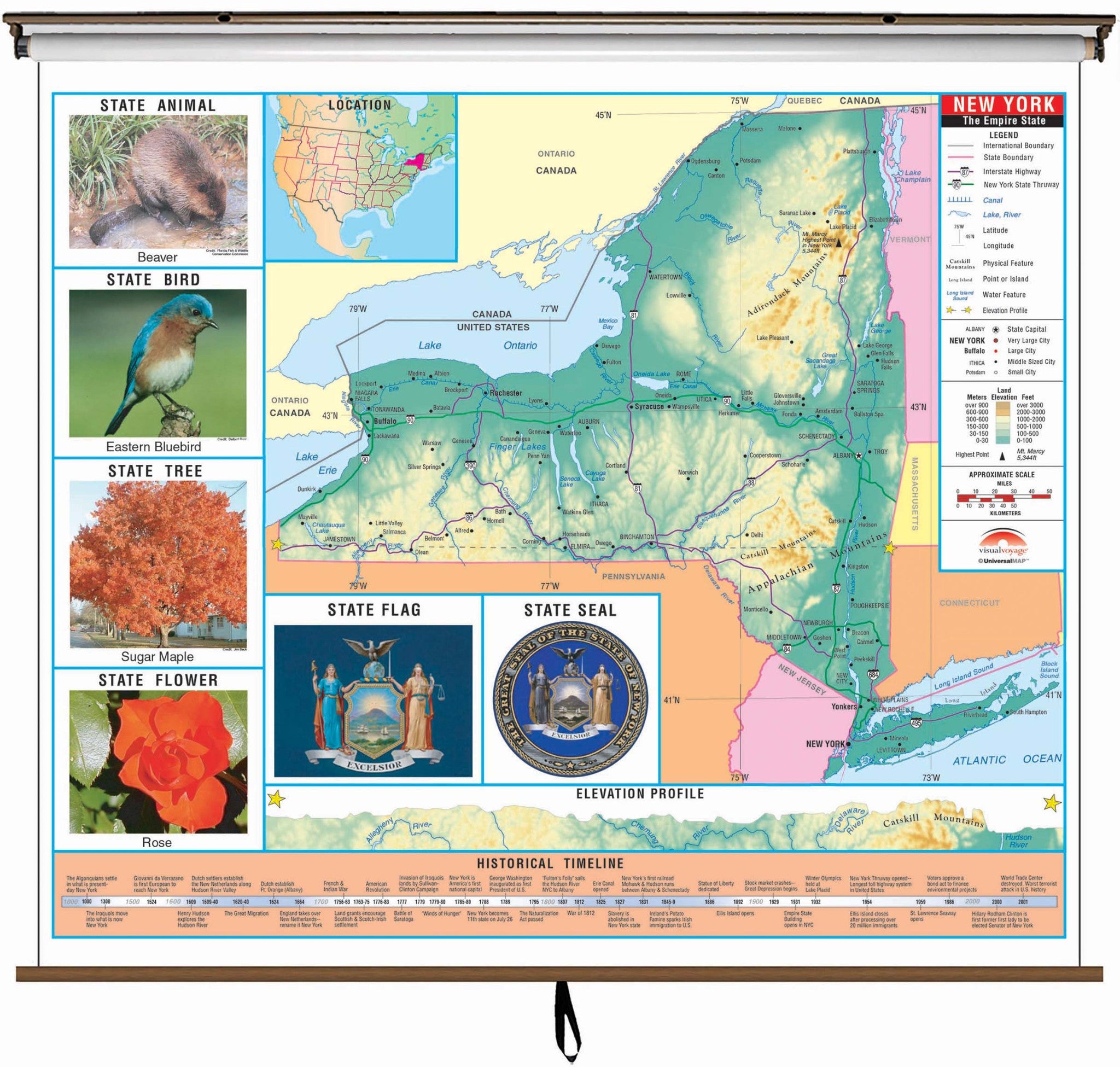
New York Topographical Wall Map by Raven Maps, 43" x 59"
Sold out
Quick View
New York Topographical Wall Map by Raven Maps, 43" x 59"
Price
$ 49.95
—
$ 74.95
Nicollet 16 Inch Illuminated Desktop World Globe By National Geographic
Sold out
Quick View
Nicollet 16 Inch Illuminated Desktop World Globe By National Geographic
Price
$ 295
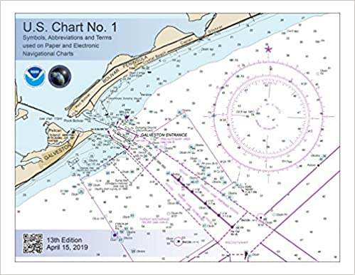
NOAA Chart No. 1; Nautical Chart Symbols and Terms
Quick View
NOAA Chart No. 1; Nautical Chart Symbols and Terms
Price
$ 14.95
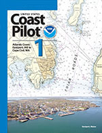
NOAA Coast Pilot 1: Atlantic Coast: Eastport, Maine to Cape Cod
Quick View
NOAA Coast Pilot 1: Atlantic Coast: Eastport, Maine to Cape Cod
Price
$ 35
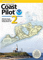
NOAA Coast Pilot 2: Atlantic Coast: Cape Cod, Massachusetts , New Jersey
Quick View
NOAA Coast Pilot 2: Atlantic Coast: Cape Cod, Massachusetts , New Jersey
Price
$ 35
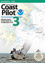
NOAA Coast Pilot 3: Atlantic Coast: Sandy Hook, New Jersey, Virginia
Quick View
NOAA Coast Pilot 3: Atlantic Coast: Sandy Hook, New Jersey, Virginia
Price
$ 35
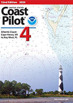
NOAA Coast Pilot 4: Atlantic Coast: Cape Henry, Virginia, Florida
Quick View
NOAA Coast Pilot 4: Atlantic Coast: Cape Henry, Virginia, Florida
Price
$ 35
NOAA Coast Pilot 5: Gulf of Mexico, Puerto Rico, Virgin Islands
Quick View
NOAA Coast Pilot 5: Gulf of Mexico, Puerto Rico, Virgin Islands
Price
$ 35
NOAA Coast Pilot 6: Great Lakes and their connecting waters
Quick View
NOAA Coast Pilot 6: Great Lakes and their connecting waters
Price
$ 35
NOAA Coast Pilot 7: Pacific Coast: California
Quick View
NOAA Coast Pilot 7: Pacific Coast: California
Price
$ 35
NOAA Coast Pilot 8: Alaska: Dixon Entrance to Cape Spencer
Quick View
NOAA Coast Pilot 8: Alaska: Dixon Entrance to Cape Spencer
Price
$ 35
NOAA Coast Pilot 9 Alaska: Cape Spencer to Beaufort Sea
Quick View
NOAA Coast Pilot 9 Alaska: Cape Spencer to Beaufort Sea
Price
$ 35
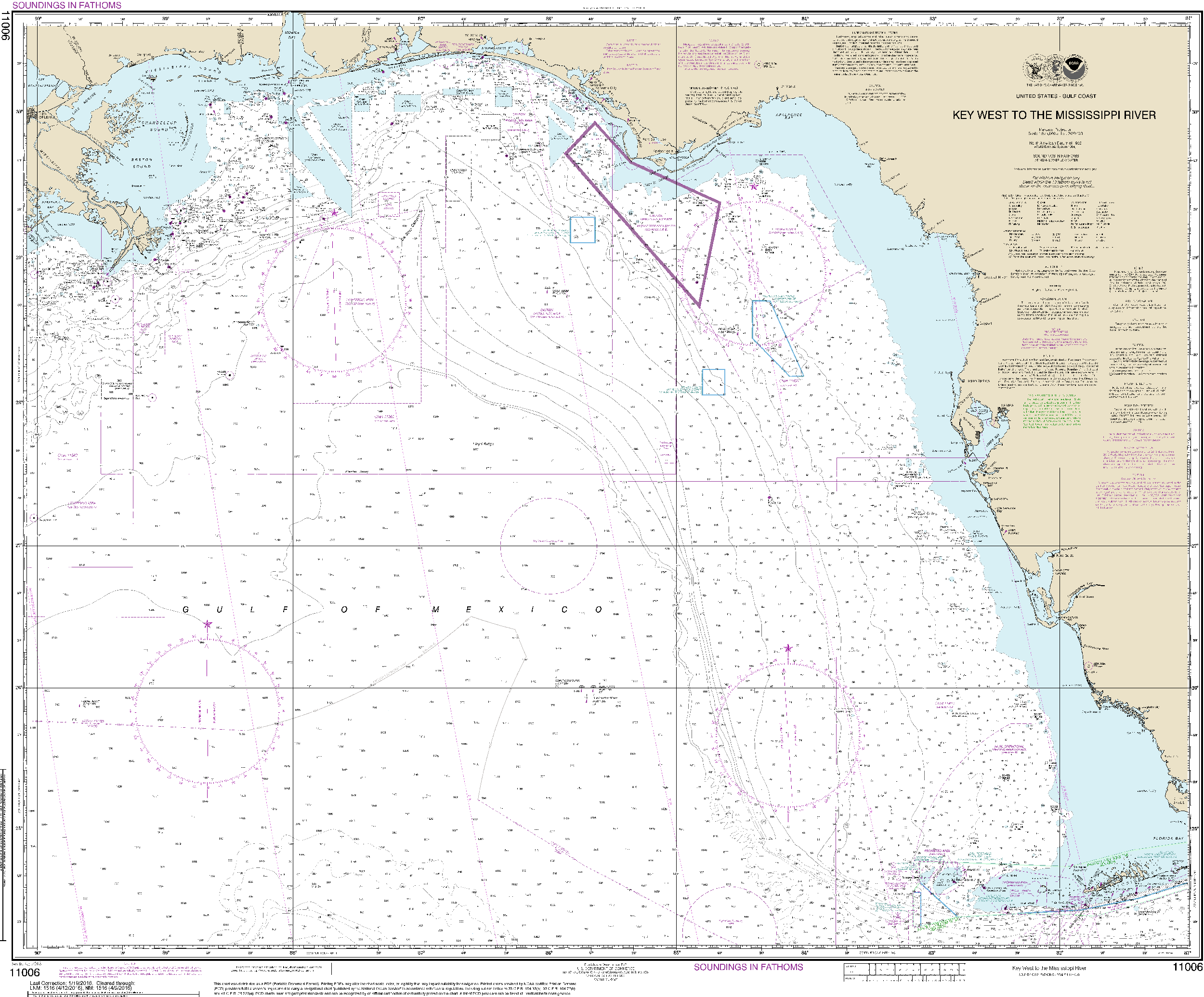
NOAA Nautical Chart 11006: Gulf Coast - Key West to Mississippi River
Quick View
NOAA Nautical Chart 11006: Gulf Coast - Key West to Mississippi River
Price
$ 26.95
—
$ 38.95
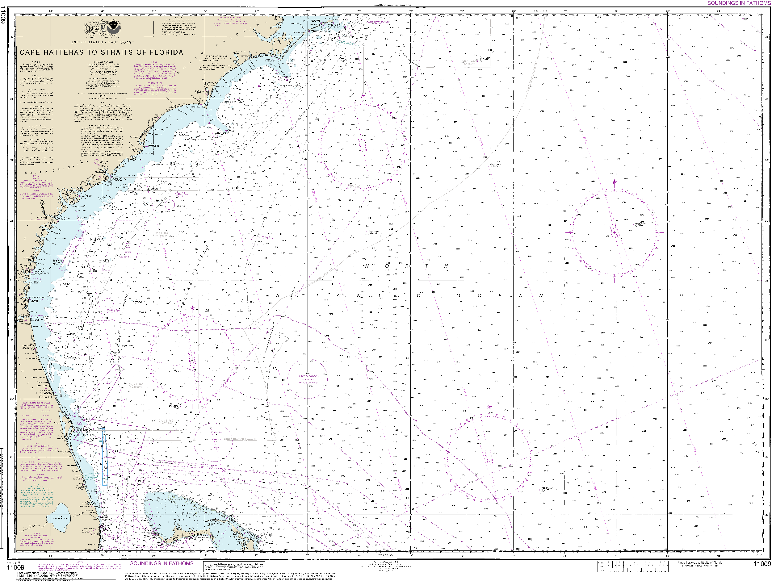
NOAA Nautical Chart 11009: Cape Hatteras to Straits of Florida
Quick View
NOAA Nautical Chart 11009: Cape Hatteras to Straits of Florida
Price
$ 26.95
—
$ 38.95
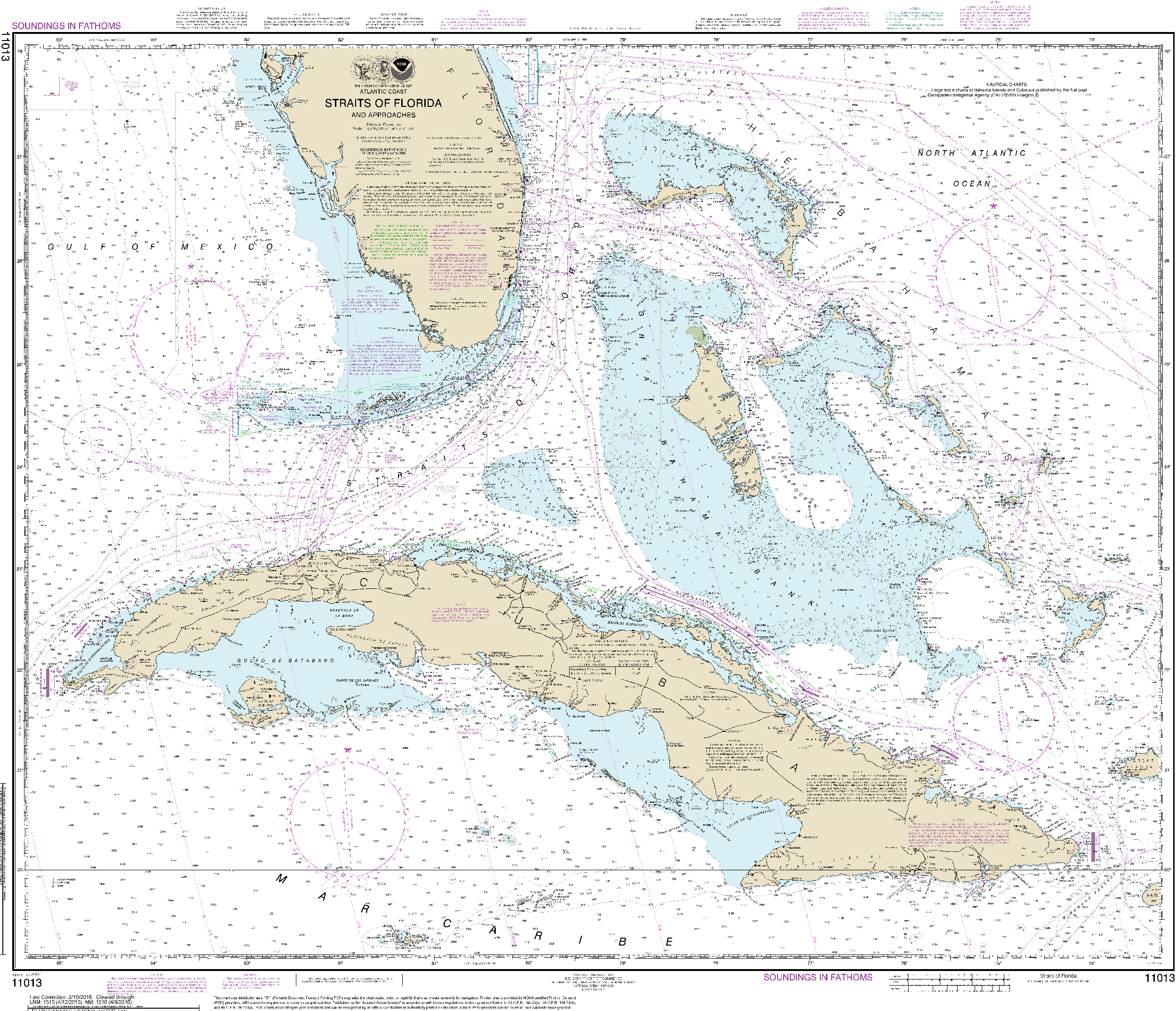
NOAA Nautical Chart 11013: Straits of Florida and Approaches
Quick View
NOAA Nautical Chart 11013: Straits of Florida and Approaches
Price
$ 26.95
—
$ 38.95
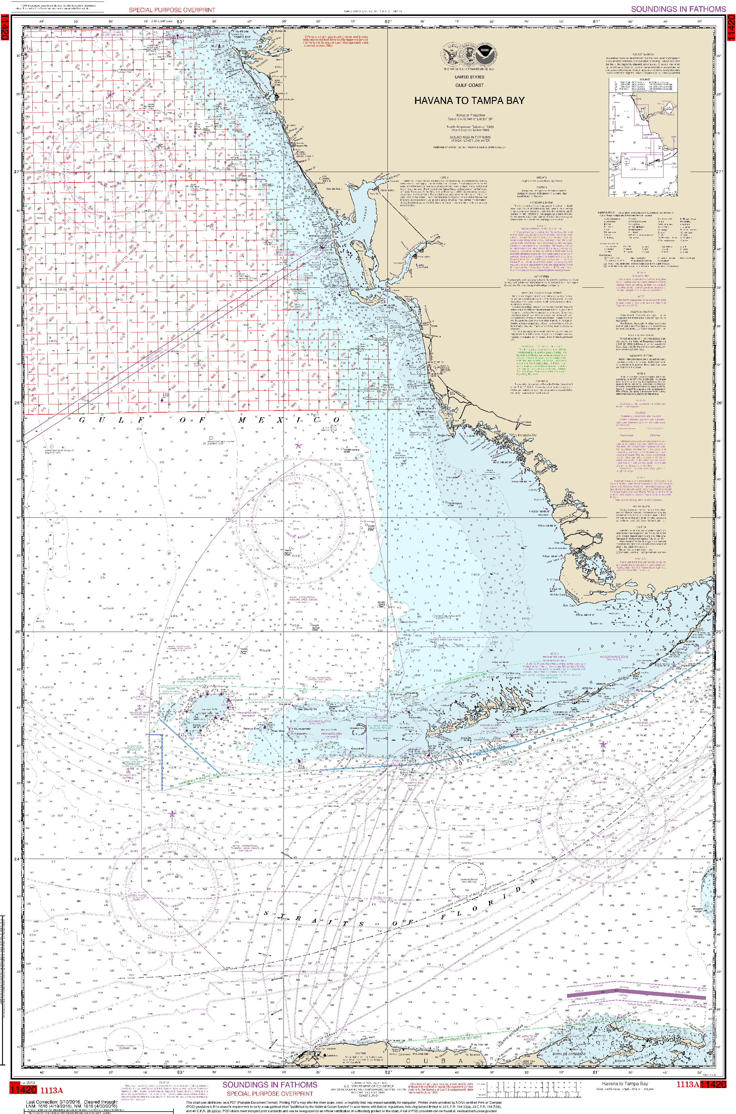
NOAA Nautical Chart 1113A: Havana to Tampa Bay (Oil and Gas Leasing Areas)
Quick View
NOAA Nautical Chart 1113A: Havana to Tampa Bay (Oil and Gas Leasing Areas)
Price
$ 26.95
—
$ 38.95
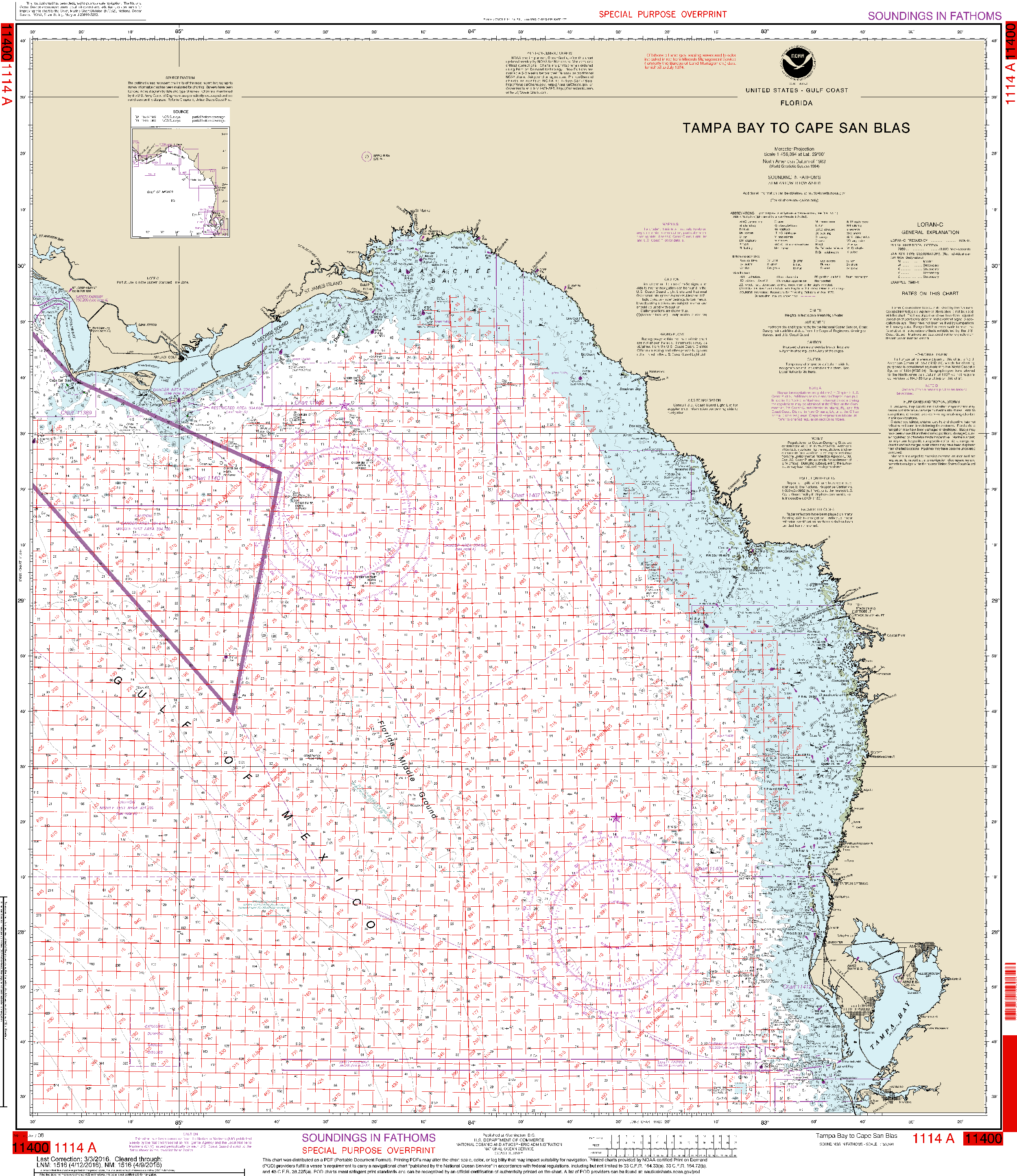
NOAA Nautical Chart 1114A: Tampa Bay to Cape San Blas (Oil and Gas Leasing Areas)
Quick View
NOAA Nautical Chart 1114A: Tampa Bay to Cape San Blas (Oil and Gas Leasing Areas)
Price
$ 26.95
—
$ 38.95
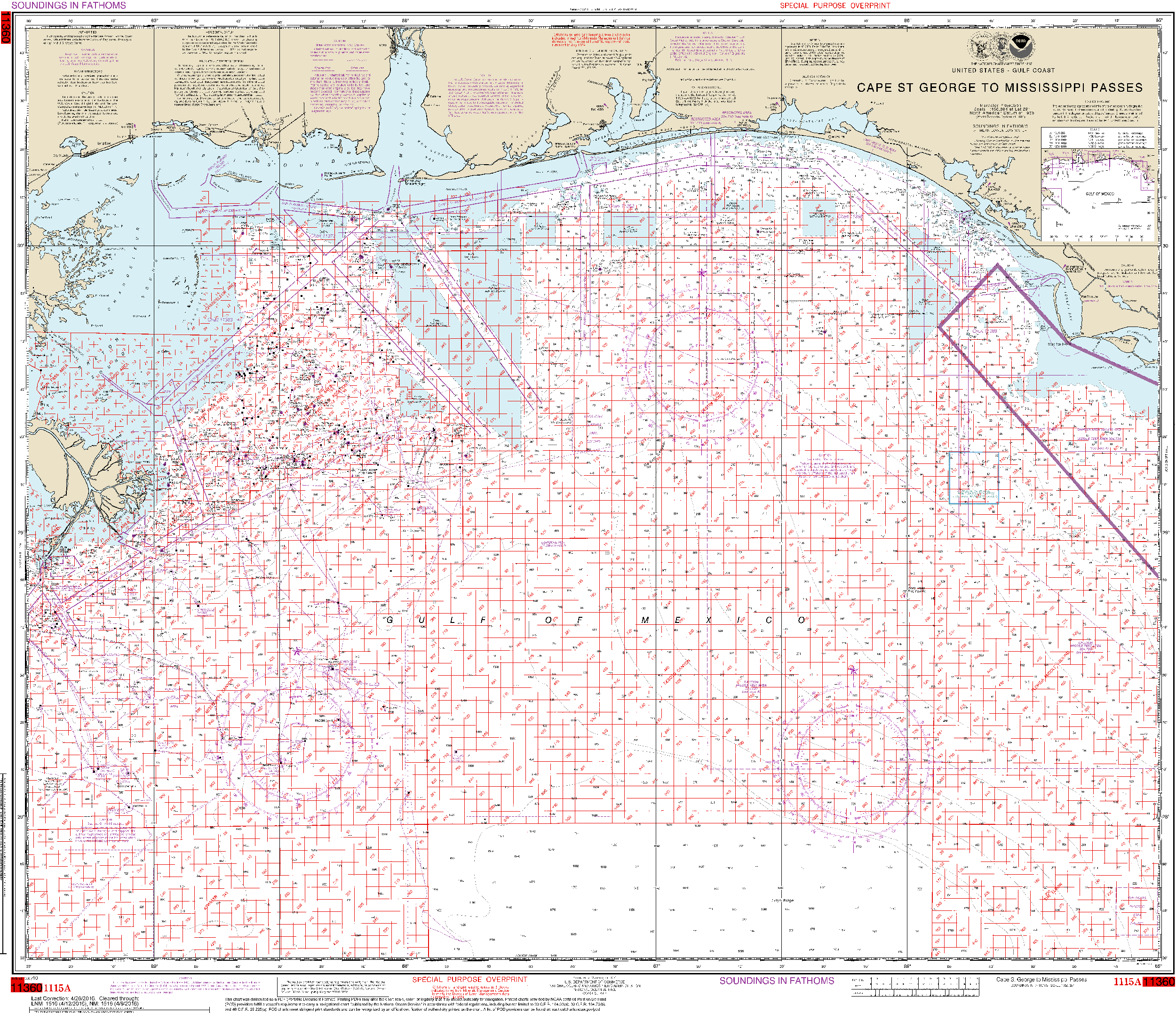
NOAA Nautical Chart 1115A: Cape St. George to Mississippi Passes (Oil and Gas Leasing Areas)
Quick View
NOAA Nautical Chart 1115A: Cape St. George to Mississippi Passes (Oil and Gas Leasing Areas)
Price
$ 26.95
—
$ 38.95
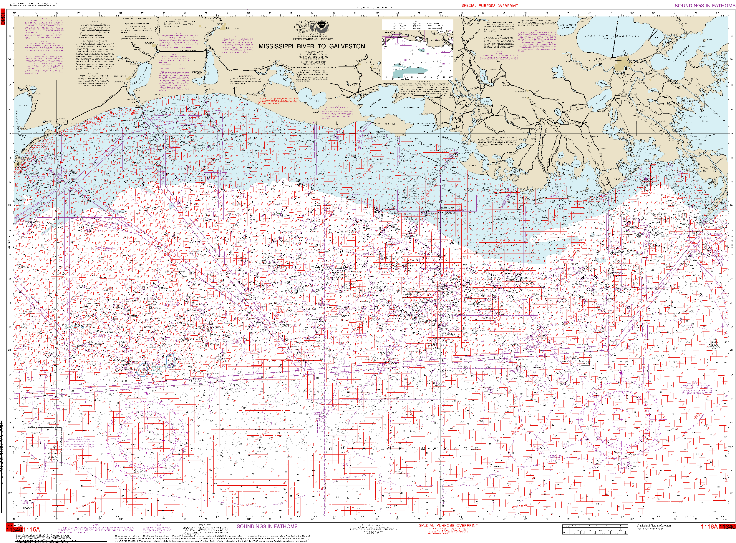
NOAA Nautical Chart 1116A: Mississippi River to Galveston (Oil and Gas Leasing Areas)
Quick View
NOAA Nautical Chart 1116A: Mississippi River to Galveston (Oil and Gas Leasing Areas)
Price
$ 26.95
—
$ 38.95
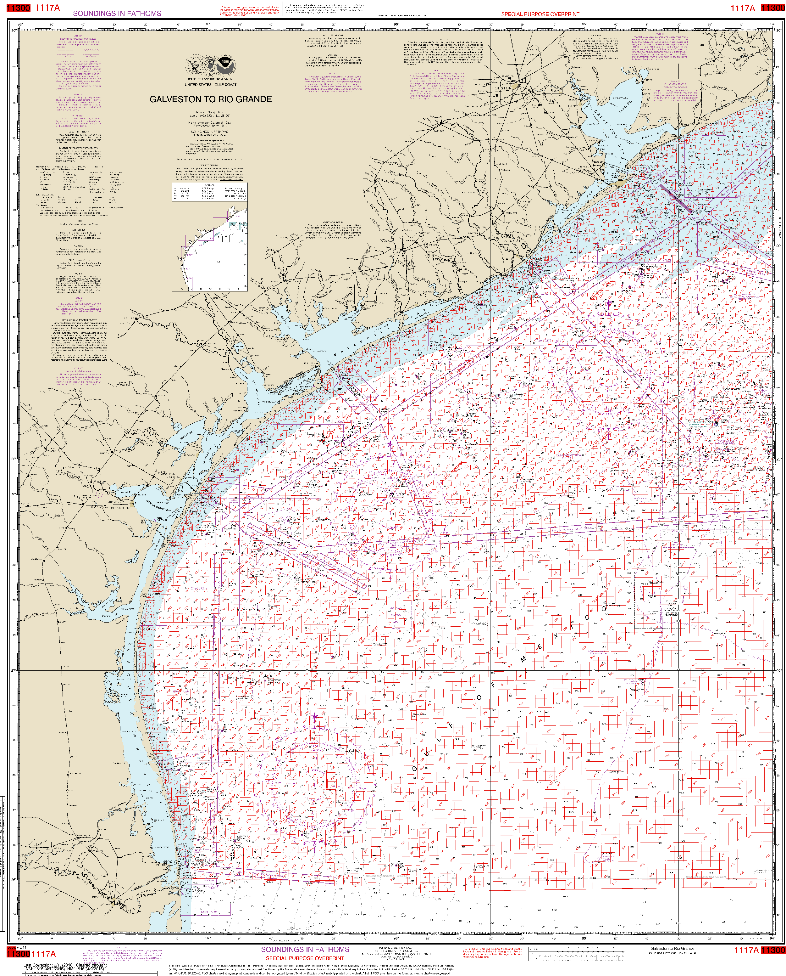
NOAA Nautical Chart 1117A: Galveston to Rio Grande (Oil and Gas Leasing Areas)
Quick View
NOAA Nautical Chart 1117A: Galveston to Rio Grande (Oil and Gas Leasing Areas)
Price
$ 26.95
—
$ 38.95
Filter
1
…
82
83
84
85
86
…
148
Choosing a selection results in a full page refresh.
✕
Added to cart
Check out
Go to Cart
Customers Also Bought