Menu

Maps have long been a gateway to understanding our world, but a particular type of map offers a unique and enchanting perspective that truly stands out—raised relief maps. In this blog post, we will explore the magic of raised relief maps, diving into how these incredible tools can transform the way we see our planet. From historical roots to their engaging three-dimensional representations, raised relief maps have delighted educators, travelers, and cartography enthusiasts for centuries. They not only elevate the traditional mapping experience but also serve as fantastic educational resources and stunning decorative elements. Join us as we delve into the rich history of raised relief maps, discover how they work, explore their various benefits and uses, and learn how you can incorporate these remarkable maps into your life. Get ready to see the world differently!

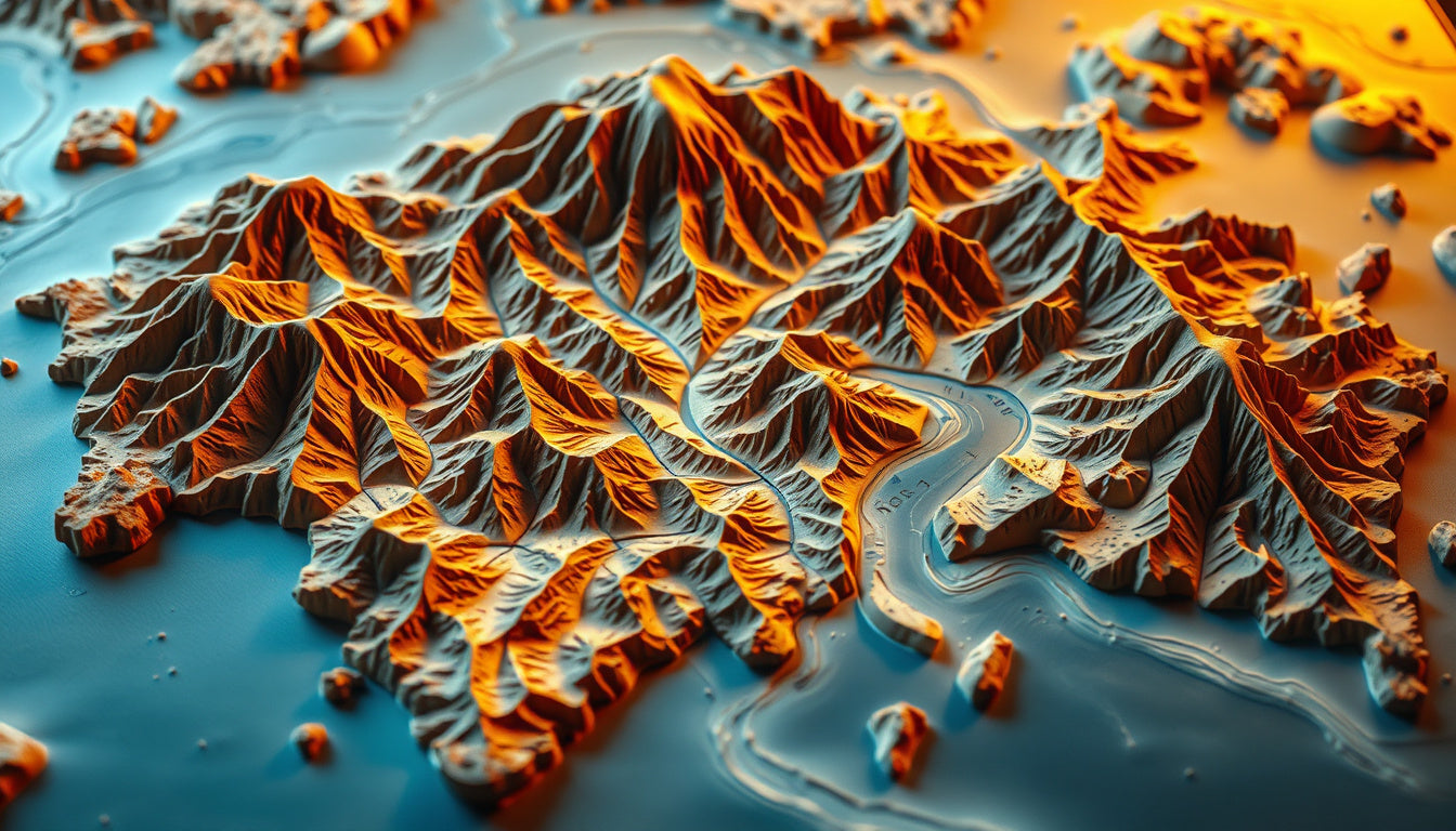
When it comes to exploring the world's landscapes and geographical features, traditional flat maps can sometimes fall short in conveying the true essence of our planet’s beauty. Enter raised relief maps, a captivating and educational tool that allows you to see the world differently. These unique maps provide a tactile and three-dimensional perspective on topography, enabling users to truly appreciate the contours and elevations of mountains, valleys, and plains. A raised relief map transforms geographical data into a delightful experience, making it an essential addition for anyone interested in geography, education, or even home décor. Whether you are a teacher looking to spark curiosity in your students, a traveler dreaming of your next adventure, or a map enthusiast seeking a stunning visual display, raised relief maps offer an innovative way to interact with the Earth's features. With GeoMart’s extensive selection, you can find the perfect raised relief map that captures the beauty of the world in stunning detail, inviting you to explore more. Let's dive deeper into the charm and utility of raised relief maps and discover why they are so magical!
### The History of Raised Relief Maps Raised relief maps, which allow viewers to physically feel the features of terrain such as mountains, valleys, and plains, have a rich and intriguing history that dates back centuries. These tactile representations began gaining popularity in the 18th century when cartographers first started incorporating three-dimensional elements into their designs, driven by a desire to provide not just visual representation, but also a tangible understanding of geography. Early incarnations of raised relief maps were often carved from wood or created using plaster techniques. This innovative method allowed educators, explorers, and enthusiasts alike to grasp the complexities of the Earth's surface in ways that flat maps could not achieve. As the demand for better navigational tools and educational resources grew, so did the technology behind raised relief maps. By the 19th century, these maps were being produced in a variety of materials, including paper and cardboard, making them more accessible for classrooms and individual use. The effectiveness of these maps in teaching geography and an appreciation for the natural world contributed to their increasing prominence in educational settings. Raised relief maps continued to evolve throughout the 20th century, with advancements in materials and manufacturing processes allowing for even greater detail and accuracy. Mapmakers began utilizing new techniques such as vacuum-forming and injection molding to create more complex and durable maps that accurately represented the topography of various regions around the globe. This period also saw the introduction of topographic relief maps—designed specifically to illustrate changes in elevation and geological structure, thereby enhancing their educational value. Today, raised relief maps are not only used in schools and universities but have also become popular decorative pieces that adorn offices and homes. These maps invite curiosity and inspire exploration, enabling individuals to 'see the world differently' through a sensory engagement with the landscape. At GeoMart, we celebrate this rich history and the educational potential of raised relief maps by offering a diverse selection that aligns with our commitment to quality and craftsmanship. Whether you’re a teacher looking to enrich your curriculum or a geography enthusiast wanting to add a unique touch to your decor, our raised relief maps can help you appreciate the intricacies of our world while enhancing your space.
'The mind is like a parachute. It doesn't work if it is not open.' - Frank Zappa

### How Raised Relief Maps Work Raised relief maps are a unique and captivating way to visualize the Earth's terrain, providing a three-dimensional perspective of geographic features. These maps blend cartography with physical modeling, allowing users to see the world differently. At their core, raised relief maps are created by shaping a relatively flat map into a three-dimensional form, accentuating mountains, valleys, hills, and other landforms. The process often involves layering materials to represent height variations accurately. This technique relies on elevation data collected through various methods such as satellite imagery, topographic surveys, and existing geological information. Because of their tactile nature, raised relief maps allow users to interact with the geography in a tangible way, offering a richer understanding of how landforms affect ecosystems, climates, and human activity. In an educational context, these maps are invaluable tools for teaching geography, geology, and environmental science. They inspire curiosity and engagement among students, practically bringing the subjects to life by illustrating concepts like mountain ranges, watershed areas, and tectonic plate movements. Raised relief maps also serve decorative uses in homes and offices, transforming walls into artistic displays of natural beauty. At GeoMart, we offer a wide selection of raised relief maps that not only engage the mind but also beautify your space, providing both aesthetic appeal and educational value.
### The Benefits of Using Raised Relief Maps
Raised relief maps are an extraordinary tool that allow us to truly 'see the world differently' by offering a tactile and three-dimensional perspective of geographical features. Unlike traditional flat maps, raised relief maps are molded to illustrate the variations in terrain, such as mountains, valleys, and plains. This added dimension makes them not only visually appealing but also highly functional for a variety of uses.
1. Enhanced Understanding of Geography:
Raised relief maps offer an engaging way to learn about topography. Whether in a classroom setting or at home, educators and students alike can benefit from the real-world representation of landforms. The tactile experience of feeling the contours enhances memory retention, making lessons on geology and geography much more impactful.
2. Aesthetic Appeal:
These maps are beautiful pieces of art that can elevate any space, from living rooms to classrooms. A raised relief map serves as a decorative element that sparks conversation and curiosity, inviting guests and students to explore its intricacies. The visual depth created by the raised features transforms an ordinary map into an eye-catching focal point that beautifully complements your decor.
3. Practical Uses for Outdoor Enthusiasts:
For hikers, geologists, or outdoor lovers, raised relief maps can provide invaluable insights into terrain and elevation changes, helping to plan adventures more effectively. Understanding elevation will assist in preparing for hikes or climbs, offering insights into the level of difficulty one might encounter.
4. Historical and Educational Value:
Raised relief maps can be historical treasures, depicting geographical features from the past and offering a lens into the geological history of an area. These maps can be used to explore ancient civilizations, understand historical trade routes, or visualize how landscapes have changed over time.
5. Accessible to All:
Raised relief maps provide an inclusive way for individuals with visual impairments to engage with maps, allowing them to 'see' the topography through touch. This accessibility can foster a greater appreciation for our planet's diverse landscape among all users.
At GeoMart, we pride ourselves on offering an extensive selection of raised relief maps that are crafted with meticulous attention to detail. Our maps not only capture the beauty and wonder of the world around us but also serve as educational tools that inspire curiosity and understanding. By choosing a raised relief map from GeoMart, you invest in a product that not only beautifies your space but also enriches your knowledge of geography.

## Popular Uses of Raised Relief Maps Raised relief maps offer a unique and engaging way to visualize and understand our world. These tactile representations allow viewers to appreciate the three-dimensional aspects of various landscapes, making them not just informative but also captivating. ### Educational Purposes One of the most popular uses of raised relief maps is in educational settings. Teachers and students alike benefit from the hands-on experience that these maps provide. By feeling the elevations and depressions of mountain ranges, valleys, and plateaus, students can gain a better grasp of topographical concepts. This interactive element enhances learning and retention, making geography lessons more engaging. At GeoMart, we offer a variety of raised relief maps that cater to different educational levels, from elementary school to advanced studies. ### Home Decor and Aesthetics Beyond their educational value, raised relief maps serve as stunning home decor items. They can transform any space by adding both style and substance. Whether you’re a passionate traveler looking to showcase your love for the great outdoors or a history buff wanting to highlight significant geographical features, raised relief maps can be customized to reflect your personal interests. These maps spark conversations and inspire wanderlust, making them perfect decorative pieces for your living room or office. Explore GeoMart's selection of beautifully crafted raised relief maps to find one that complements your style. ### Planning and Exploration For outdoor enthusiasts and explorers, raised relief maps are invaluable tools for planning adventures. Hikers, climbers, and bikers utilize these maps to identify terrains, elevation changes, and natural features, allowing for better preparation before embarking on their journeys. The tactile aspect of raised relief maps allows adventurers to mentally navigate through their routes, making it easier to anticipate challenges and enjoy the beauty of nature. GeoMart provides a wide range of raised relief maps tailored for different outdoor activities, ensuring you have the right tool for your next excursion. ### Accessibility for All Raised relief maps also play a crucial role in accessibility. They can be used to assist visually impaired individuals in comprehending geographic locations and features through touch. Local schools, libraries, and organizations often utilize these maps to create inclusive environments, ensuring that everyone has the opportunity to explore and learn about our planet. At GeoMart, we recognize the importance of accessibility and offer raised relief maps that cater to diverse needs, highlighting our commitment to education and inclusion. ### Collectible Art Many collectors find joy in owning unique raised relief maps as pieces of art. These maps can showcase detailed artistry and craftsmanship, making them essential additions to any art collection. Whether focusing on a specific region or a historical perspective, collectors appreciate the depth that raised relief maps bring to their collections. GeoMart supplies a variety of collectible raised relief maps, allowing enthusiasts to curate their own impressive displays. In summary, raised relief maps provide a multi-dimensional perspective on our world. From learning and exploration to decoration and accessibility, their applications are vast and varied. Whether you're a teacher, adventurer, decorator, or collector, raised relief maps offer unique benefits and uses. To see the world differently, explore the enchanting selection of raised relief maps available at GeoMart, where quality meets creativity.
In conclusion, raised relief maps offer a unique and enchanting way to see the world differently. By transforming flat representations of our planet into three-dimensional, tactile displays, these maps provide not only a visually striking addition to your home or educational space but also an interactive experience that fosters greater understanding of geographical features. Whether you're an educator seeking to captivate your students’ imaginations, a globe-trotter managing your travel aspirations, or a parent looking to spark a love for geography in your child, raised relief maps serve as powerful tools. They bridge the gap between learning and visual engagement, enabling viewers to truly appreciate the contours of mountains, valleys, and other geographical wonders. At GeoMart, we understand the significance of such educational and decorative elements, which is why we offer a wide selection of high-quality raised relief maps designed to inspire and inform. Exploring our collection will not only enrich your environment but also provide you an opportunity to see our magnificent world from a brand-new perspective. Dive into the world of maps at GeoMart.com today and discover how these remarkable pieces can transform your understanding of geography!